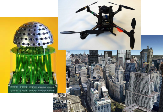
The terrestrial mapping of urban environments with a sub-decimeter accuracy remains largely an open problem due to the poor availability of a reliable GNSS signal in those scenarios. As a potential solution, the TOPO Lab is exploring the concept of a micro-UAV-aided mobile mapping platform. In particular, the trade-off between the wide field-of-view and the ground resolution of an airborne optical sensor constitutes a major constraint for the effective realization of such concept. Consequently, we consider the utilization of a breakthrough visual sensor recently developed by the Signal Processing (LTS2) and the Microelectronic Systems (LSM) laboratories at EPFL, namely the Panoptic camera, which facilitates an omnidirectional, three-dimensional perception of the surrounding, while allowing for a super-resolution information to be selectively extracted from the redundant visual data.
The proposed project aims at demonstrating the feasibility, as well as developing the necessary algorithmic workflow for a sub-decimeter localization of terrestrial objects using the visual data from a micro UAV-mounted panoptic camera.