Overview of what is possible to find on the map via the following buttons:![]() and
and ![]()
![]() The hamburger button integrated into the search bar allows you to:
The hamburger button integrated into the search bar allows you to:
- browse among all the EPFL branches (campus)
- display geolocated elements classified by themes (access, shops, etc.)
- select “points of interest”, customizable, to check
![]() Via the button in the shape of a hamburger, and by clicking on the entry ‘EPFL beyond Lausanne’, the maps of the campuses of Neuchâtel, Fribourg, Valais, Middle East as well as other EPFL premises in Lausanne (Ecal Renens, Aula des Cèdres …)
Via the button in the shape of a hamburger, and by clicking on the entry ‘EPFL beyond Lausanne’, the maps of the campuses of Neuchâtel, Fribourg, Valais, Middle East as well as other EPFL premises in Lausanne (Ecal Renens, Aula des Cèdres …)
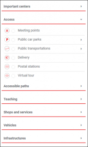
This function allows you to select which content should be displayed on the map. By default, “Important centers” and “Public transportations” are registered. You can add them as you wish by checking them in the lists offered.
![]() Via the menu in the form of an hamburger, display the geolocation of elements related to Access, Important centers, Accessible paths, Shops and services, Vehicles, Teaching …
Via the menu in the form of an hamburger, display the geolocation of elements related to Access, Important centers, Accessible paths, Shops and services, Vehicles, Teaching …
To obtain the pdf of the equipment and capacities of a classroom :
- look for the room
- click on the green rectangle
- a dialog box containing the .pdf is displayed
This function allows you to build a route between two points located on the EPFL campus. There are two ways to do this :
1. With the search bar
![]()
![]() After entering the search subject in the field, just click on the icon to trigger the opening of the route zone.
After entering the search subject in the field, just click on the icon to trigger the opening of the route zone.
2. With the route zone
By opening the route zone with the icon ![]() the following menu is displayed :
the following menu is displayed :
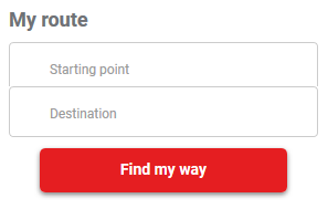
You just have to indicate your starting point as well as your ending point, and launch the search using the “Find my way” button. If several people or premises correspond to the starting or arrival point, you will be asked to choose one from the list of possibilities.
Please note that the itinerary may not take into account the closing of certain doors due to the limitation of the CAMIPRO system.
Toggle between an aerial view and plan view by clicking on the icon ![]() then on the red link “View”.
then on the red link “View”.
In addition to the zoom functions, the geolocation button allows your web browser to share your location (integrated geolocation)
![]()
Via the button ![]() on the right, access the link in red ‘Print’, which allows you to generate a .pdf (A4 or A3), specifying a print area.
on the right, access the link in red ‘Print’, which allows you to generate a .pdf (A4 or A3), specifying a print area.
By default, level ‘0’ is displayed on a map. To view another level, use the horizontal buttons :
The search area is a unique field that allows you to enter :
- a name, a first name or a SCIPER number to find a person
- the name of a room, with or without a space (eg C0160, C0 160)
- the name of a commodity (e.g. library, M1, cafeteria, etc.)
then, via the ‘Route’ button ![]() , obtain the route to get to the room found.
, obtain the route to get to the room found.
The red link ‘Reset’, present in via the button ![]() , allows you to return to the default map screen, deleting all the searches and layers previously displayed.
, allows you to return to the default map screen, deleting all the searches and layers previously displayed.