Supercell thunderstorms in the Alpine region
Supercell thunderstorms are particularly severe, single thunderstorm cells that are characterised by their internal rotation. They are responsible for severe weather ranging from torrential rain over windgusts to hail and even tornadoes. Insurances list them as the leading cause of weather-related damage.
Supercells are most common in the Great Plains of the United States, but they do also occur in Switzerland. Here, they mainly occur as hailstorms, consequently affecting agriculture, infrastructure and property.
This research established an automatic detection of supercells in the Swiss operational radar data. An archive of all events since 2016 characterizes the spatio-temporal occurrence patterns within the observational domain. Further research compared this database to severe hail- and rainstorms during the same period, providing further context for the intensity of supercells and their associated hazards. By deriving the key characteristics of supercell occurrence in this orographically complex region, key features have been reproduced in idealized modeling scenarios, allowing the identification of underlying meteorological drivers that impact the development.
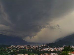
Supercell thunderstorm as observed from Locarno-Monti (copyright Luca Panziera)
Researcher: Monika Feldmann
Radar measurements of hail size
Starting in 2018, a network of hailsensors has been installed in three separate regions of Switzerland. Each hailsensor measures the kinetic energy of the falling hailstones, which can be used to estimate their diameter. The distribution of the diameters recorded by the sensors is commonly known as Hail Size Distribution (HSD).
While the HSD measured at different locations and times may vary significantly, there are some properties of the distribution that remain constant. One of these properties is the “shape”: we can estimate a curve that, after some scaling, fits sufficiently well the various HSD.
The technique used for this scaling allows us to describe the HSD using only two parameters.
Using the measurements collected by the Swiss radar network, we are currently investigating the relationship between the polarimetric radar variables and these parameters.
The final goal of this research is the development of new radar products: one or more indices to estimate some properties of the HSD at the ground, using only operational radar measurements.

Researcher: Alfonso Ferrone
Localized Intense Rain Events
This project conducted in collaboration between EPFL and MeteoSwiss and falling within the larger context of the Radar4Infra Innosuisse project, focuses on the use of high-resolution radar data for the analysis of Localized Intense Rain Events (LIRE) in Switzerland. Such events leading to flash floods, debris flow or landslides are regularly causing significant societal and economic damages. Improving our understanding on these events is therefore crucial to guarantee the safety of the population and the protection of infrastructures. Because of their high-spatio temporal variability, the detection and the forecasting of such events remains however particularly challenging and uncertain. These events indeed typically develop over very small spatial and temporal scales that are particularly difficult to properly capture in current meteorological products.
The objective of this PhD research is to use the MeteoSwiss native raw radar data available at high spatial (83 m) and temporal (2.5 min) resolution for the analysis of LIRE. In particular the aim is to assess how the high spatiotemporal resolution provided by weather radar can be leveraged to improve the detection and, consequently, the forecasting of hydro-meteorological hazards associated with LIRE in Switzerland.
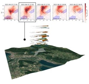
Spatial distribution of high-resolution radar data over the watershed of the Ruhaut river (Cressier (NE) – Switzerland) highlighting the variability in rain rate estimates during the storm event of 22nd June 2021
Researcher: Adrien Liernur