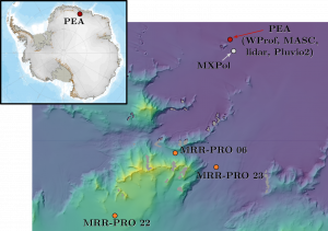
The PEA Orographic Precipitation Experiment is a measurement campaign that took place at the Belgian research base Princess Elisabeth Antarctica (PEA) during the Austral summer 2019-2020.
The station is located in Queen Maud Land (East-Antarctica), at about 1380 m a.m.s.l., at the foot of the Sør Rondane Mountains.
Due to the presence of mountains of almost 3000m of altitude in a 25km radius from the station, the main goal of the campaign is studying the effects of the complex orography on clouds and snowfall at the site.
LTE deployed a cloud profiler (WProf), three smaller radar profilers (MRR-PRO), a scanning precipitation radar, a Multi-Angle Snowflake Camera (MASC), a rain gauge (Pluvio2) and a lidar at the base.
The cloud profiler
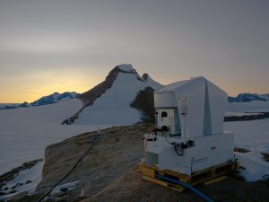
WProf is a W-band, Doppler, vertically-pointing, Frequency Modulated Continuous Wave (FMCW) cloud radar. It was installed on a small wooden platform few meters south of the base, close to one of the scientific containers.
Given the high frequency (94 GHz) and sensitivity of the instrument, we were able to collect very detailed information on both the cloud and precipitation up to approximately 10 km above the site.
The three radar profilers
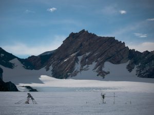
The Micro Rain Radar PRO (MRR-PRO) is a Doppler, FMCW profiler operating at 24 GHz (K-band). Its small size and low power consumption made it the ideal candidate for deployment in remote sites, with no direct access to the main power grid of PEA.
We deployed each of the radar in a different locations, several kilometers away from the station and from each other. The first one was positioned at approximately 2000 m of altitude, in the middle of a small group of mountains. The second one was located at a lower altitude, in a relatively large valley coming down from the plateau. The last one was at the limits of the plateau, at the highest altitude among the three, on the south side of the mountains.
Each radar was accompanied by a set of solar panels and a battery that allowed for their continuous operation for over a month, with only few maintenance trips during the campaign.
The other instruments
The X-band, scanning, Doppler, dual-polarization precipitation radar was installed few kilometers away from the station, to maximize the visibility on the mountains.
The MASC and the lidar were both deployed on the rooftop of the base. Unfortunately, the latter the latter was affected by some technical problems, which undermined the data acquisition.
The Pluvio2 was deployed few meters away from WProf.