- Water optical properties near the LéXPLORE Platform and Sentinel satellite images are used to characterise Chlorophyll-a and turbidity in Lake Geneva with the goal to quantify primary productivity over the entire lakes surface area over the annual cycle. (Camille Minaudo, Daniel Odermatt)
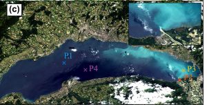
Figure shows Landsat-8 image of Lake Geneva on June 15, 2014. The insets zoom (top right) show the Rhône inflow area. The bright regions indicate a whiting event, typical in early summer.
- Nouchi, V., T. Kutser, A. Wüest, B. Müller, D. Odermatt, T. Baracchini, and D. Bouffard. (2019). Resolving biogeochemical processes in lakes using remote sensing. Aquatic Sciences 81(2): 27, https://doi.org/10.1007/s00027-019-0626-3.
Nouchi, V., D. Odermatt, A. Wüest, and D. Bouffard. (2018). Effects of non-uniform vertical constituent profiles on remote sensing reflectance of oligo- to mesotrophic lakes. European Journal of Remote Sensing 51(1): 808–821. doi.org/10.1080/22797254.2018. 1493360
Soomets, T., T. Kutser, A. Wüest, and D. Bouffard (2019). Spatial and temporal changes of primary production in a deep peri-alpine lake. Inland Waters 9(1): 49-60. https://doi.org/10.1080/20442041.2018.1530529