
SURFACE
Co-Designing the Urban Surface as Socio-Ecological Interface in the Adaptation of Fribourg’s Cantonal Roads into Multimodal Passage-Paysages In recent decades, the concept of the urban surface has emerged as a crucial element in transforming public spaces worldwide. Foundational projects like Bernard Tschumi’s Parc de la Villette in Paris and more recent interventions, such as those by (…)

OPT-USE
Summary In the evolving landscape of work, hybrid models have reshaped the traditional office paradigm. As we navigate a new era where office occupancy rates are declining due to an increase in hybrid working arrangements, the importance of physical office space is being reevaluated, adding layers of complexity to the performance of building and energy (…)

LOW-CO2T
Summary Carefully extracting reinforced concrete (RC) elements and steel beam profiles from soon-to-be demolished structures and reusing them in new load-bearing systems is an emerging circular, extremely low-carbon strategy for new construction. Producing building floor systems typically accounts for the most significant part of the upfront carbon footprint of buildings. Preliminary work suggests that combining (…)

URBAGREEN
Summary The progressive loss of trees and natural vegetation during urban development necessitates a shift towards more sustainable architecture and urban planning as key solutions for fostering greener and more resilient cities. In fact, the prevalence of built structures in urban areas has led to the emergence of heat islands, intensifying the impact of climate (…)
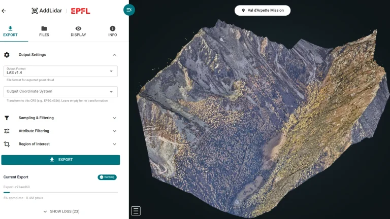
AddLidar: Automated LiDAR Processing & 3D Visualization Platform
The AddLidar platform enables researchers at EPFL’s ESO laboratory to efficiently manage, process, and visualize massive airborne LiDAR datasets through a web-based interface. Built on a Kubernetes-based infrastructure, the system automates the pipeline from raw data ingestion to interactive 3D visualization, handling datasets exceeding 100GB with automated compression, conversion, and web optimization. Researchers can upload (…)
Transition Compass Web Platform for Policy Impact on Climate
The TransitionCompass web tool enables policymakers and researchers to visualize how policy decisions impact climate outcomes. The platform uses PyCalc computational models to provide real-time projections of greenhouse gas emissions, temperature changes, and environmental indicators across transport, buildings, energy, agriculture, and industry sectors. Users adjust policy “levers”, representing regulatory approaches from strict to lax, and (…)
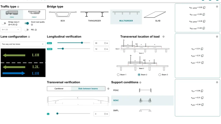
Bridge Traffic Load Web Calculator (ASTRA 82001)
The Bridge Traffic Load Web Calculator (based on norm Astra 82001) is a free online tool that helps engineers analyze bridge safety according to Swiss standards. Developed by ENAC-IT4R and RESSLab for the Federal Roads Office (FEDRO), it’s available in English, French, Italian, and German. The calculator is designed for standard bridge assessments, helping engineers evaluate (…)

Atlas of Reused Concrete
Atlas of Reused Concrete is an online platform that centralizes and showcases data on construction projects using reused concrete, supporting the transition toward more circular and low-carbon building practices. Coordinated by EPFL’s Structural Xploration Lab, the project addresses the fragmentation of existing data that limits knowledge sharing and large-scale analysis. Developed within ENAC-IT4R, the platform (…)
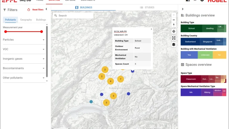
Indoor Air Quality Database
The rapid growth of smart building technologies is revolutionizing how we monitor and improve indoor air quality (IAQ). To support this transformation, the Human-Oriented Built Environment Lab (HOBEL) is building the first open-source Global IAQ Database — a curated, standardized repository of IAQ data from decades of field measurements around the world. The approach: (…)
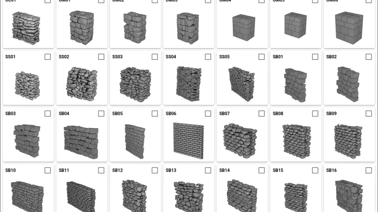
Masonry Microstructure Database
The Masonry Microstructure Database (MMS) platform is the first open-access repository of 3D microstructures of stone masonry walls. Masonry microstructure, defined by the geometry, size, shape, and spatial arrangement of individual stone units, significantly influences structural performance. The database currently includes 36 walls covering major masonry typologies. Twelve walls are real, built and scanned in (…)