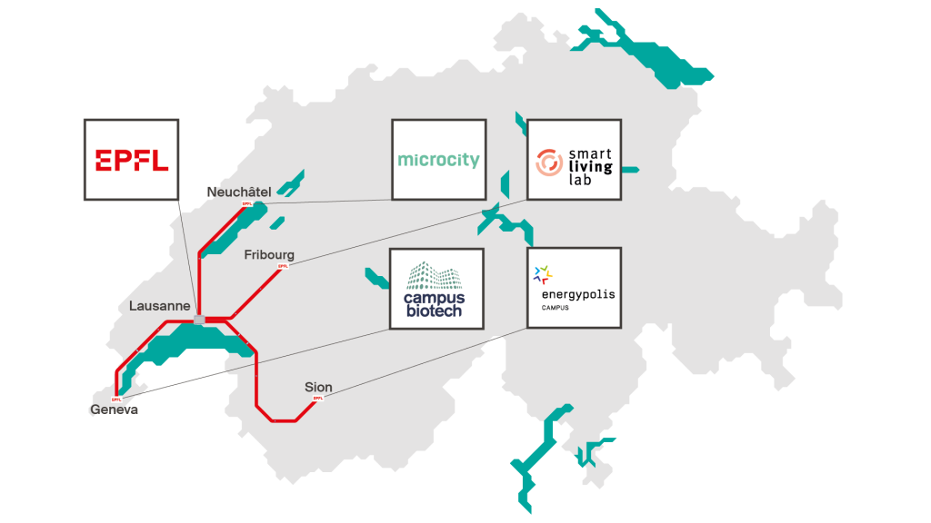
Lausanne | Genève | Fribourg | Neuchâtel | Valais
Main campus in Lausanne (Ecublens)
EPFL’s main campus is located in the commune of Ecublens in the heart of the Lausanne-Morges agglomeration, at the crossroads of several major road and rail routes. Access to the campus is guaranteed by a dense network of active mobility facilities, an efficient public transport network and excellent road connections.
EPFL buildings are accessible to people with reduced mobility. Free reserved parking spaces are available across the campus.
EPFL’s interactive plan lists the facilities and services available to people with reduced mobility. The map also lists the existing obstacles on the site.
The EPFL campus is within walking distance of the main public transport hubs. Discover the best routes to reach the campus on foot :
- From Renens train station (2.7 km, about 35 minutes)
- From Malley train station (4.9 km, about 1 hour)
- From Lausanne train station (6.3 km, about 1 hour 30 minutes)
- From LEB train station, Lausanne Flon (6.7 km, about 1 hour 40 minutes)
- From Morges train station (8.5 km, about 1 hour 45 minutes)
The EPFL campus is easily accessible by bike thanks to an extensive cycle network. There are around 3,700 parking spaces on the EPFL campus, spread over several locations, including bike racks and a secure vélostation available to the EPFL community (see interactive plan).
Discover the best cycling routes to reach the campus:
The West Lausanne municipalities have also published a cycle map (PDF, 11 MB) showing the most suitable routes for each occasion.
Thirteen PubliBike bike-sharing stations are also located on the UNIL-EPFL campus (see map of locations).
The EPFL campus is easily accessible thanks to a dense urban public transport network and its proximity to major rail connections. The site is served by the m1 metro, tl buses (1, 31) and MBC buses (701, 705).
From Lausanne station
- By bus (about 25 minutes)
- tl1 direct route towards EPFL/Colladon, stop at the terminus
- Monday to Friday from 6:00 a.m. to 6:40 p.m.
- By metro – via Le Flon (about 20 minutes)
- m2 towards Croisettes, get off at Lausanne-Flon
- m1 metro towards Renens gare : EPFL stop
From Renens station
- By bus (about 11 minutes)
- tl31 at Renens gare sud stop towards Venoge sud : UNIL-Sorge stop or Argand stop
- tl31 at Renens gare sud stop towards Venoge sud : UNIL-Sorge stop or Argand stop
- By metro (about 6 minutes)
- m1 towards Lausanne-Flon : EPFL stop
From Morges station
- By bus (about 15-20 minutes)
- MBC 701, towards Lausanne Bourdonnette : Pré-Fleuri stop, Parc Scientifique stop, Pâqueret stop or Champagne stop
- MBC 701, towards Lausanne Bourdonnette : Pré-Fleuri stop, Parc Scientifique stop, Pâqueret stop or Champagne stop
Horaires
- SBB (Swiss Federal Railways, Switzerland’s main railway company)
- Lausanne public transport (Metros and bus)
- Morges Bière Cossonay Region (bus)
By car or motorbike, from the A1 motorway
- Follow signs for Lausanne-Sud and take exit 2-St-Sulpice towards St-Sulpice/Ecublens, UNIL-EPFL.
- Join Route Cantonale 1 and continue towards St-Sulpice until you reach the EPFL campus on the right : Avenue François-Alphonse Forel, entrance to the Rolex Learning Center underground car park or Allée de Savoie
White spaces for visitors are available in the main car parks on campus, in particular at the Rolex Learning Center on the Esplanade and at the EPFL Innovation Park.
- Tarification : on working days from 7am to 5pm, CHF 1.- for the firs hour and CHF 2.- for the following hours. Outside these hours, parking on white spaces is free.
- Payment : by cash directly at the parking meter or by various dematerialized payment solutions via the Parkingpay app (iOS, android, web), the EasyPark app (iOS, android) and the Twint app (iOS, android).
Parking spaces for motorised two-wheelers are available free of charge throughout the campus. See interactive plan
Deliveries
Information desk in BS 047
Associated campuses
The associated campuses contribute to the EPFL’s three missions of education, research and innovation by operating and developing a campus on a site distant from Ecublens.
EPFL Fribourg
EPFL Fribourg is based at the Smart Living Lab, in the Halle Bleue of the bluefactory innovation district at Passage du Cardinal 13b, 1700 Fribourg. (See site map)
Parking places reserved for people with reduced mobility are available near the Garages building (no. 15, see site map).
Pedestrian routes to the campus
- From Fribourg station (1 km, about 15 minutes)
Cycling routes to the campus
- From Fribourg station (950 m, about 5 minutes)
Bike parking
- Bike parking spaces are available throughout the site.
Bike-sharing
- A PubliBike bike-sharing station is located on the bluefactory site in front of Building A. (see map of locations).
Discover the city of Fribourg’s cycle map, classifying routes according to their degree of comfort.
The EPFL Fribourg site is located close to the railway station and is served by public transport in Fribourg.
From Fribourg station
- By bus (4 minutes)
- B5 towards Villars-sur-Glâne gare : Fribourg, bluefactory stop (2 minutes)
- Take the stairs down from the Route de la Glâne to the square in front of the Halle Bleue. (2 minutes).
Timetables
- Fribourg public transport (bus, train, funicular)
- SBB (Swiss Federal Railways, Switzerland’s main railway company)
By car or motorbike, from the A12 motorway
- take exit 7-Fribourg Sud towards Fribourg-Sud
- Follow the Route de Cormanon towards Romont/Bulle until you reach the Route de la Glâne, then follow the signs for Fribourg/Marly
- Continue along Avenue du Midi and turn right onto Passage du Cardinal. (see itinerary and access map)
Parking
Paid visitor parking places are available throughout the site, as well as charging stations for electric vehicles. More information on charges and payment methods
EPFL Genève
EPFL Geneva is located at the Campus Biotech, which includes the School’s centers and laboratories, at Chemin des Mines 9, 1202 Geneva.
The entire site is accessible to people with reduced mobility. One parking space is reserved in the Campus Biotech visitor car park.
Pedestrian routes to the campus
- From Geneva station (1.5 km, about 20 minutes)
- From Genève-Sécheron station (500 m, about 6 minutes)
Cycling routes to the campus
- From Geneva station (1.9 km, about 7 minutes)
- From Genève-Sécheron station (700 m, about 3 minutes)
Bike parking
Dedicated bike parking spaces for visitors to Campus Biotech are available on the campus site. Other spots are also available on Avenue de Sécheron. Bicycles can also be parked at the bike station in the Sécheron P+R parking station (at a charge).
Bike-sharing
There are two Donkey Republic bike-sharing stations in Geneva near the Biotech Campus along the Rue de Lausanne between Avenue de la Paix and Avenue Blanc. See the locations on the app.
Geneva by bike
Discover the “Genève centre” cycle map produced by the City of Geneva, which lists recommended urban routes, including access to the Biotech campuses.
The Campus Biotech is served by the Geneva public transport system (tpg) (bus and tramay) and is located not far from the Geneva and Genève-Sécheron railway stations.
From Geneva station
- By train (about 2 minutes)
- Léman Express (CEVA) towards Coppet : Genève-Sécheron stop
- Léman Express (CEVA) towards Coppet : Genève-Sécheron stop
- By bus (about 12 minutes)
- line 1 or line 25 towards Genève, Jardin Botanique : Genève, Jardin Botanique stop
- line 1 or line 25 towards Genève, Jardin Botanique : Genève, Jardin Botanique stop
- By tram (about 10 minutes)
- T15 towards Genève Nations : Genève, Maison de la Paix stop
- T15 towards Genève Nations : Genève, Maison de la Paix stop
Timetables
- Geneva public transport (bus, tram, train)
By car or motorbike, from the A1 motorway
- Take exit 2-Genève-lac and join Route de Lausanne/Route 1.
- Follow the Route de Lausanne towards Geneva
- Turn right at Chemin des Mines/Avenue du Blanc.
Parking
Free parking spaces are available on request for occasional visits (one day or half a day) in the Campus Biotech visitor car park (level -1), which can be accessed via Chemin des Mines 9 or Rue Kazem-Radjavi.
To book a place :
- Inform your contact person at Campus Biotech that you would like a visitor parking space so that they can make a request to the car park manager (the contact person being the person receiving the visitor).
- Once at the car park, you will need to inform the security post at the barrier.
EPFL Neuchâtel
EPFL Neuchâtel is located in the Microcity innovation cluster building at rue de la Maladière 71, 2000 Neuchâtel.
Several parking lots reserved for people with reduced mobility are available in the parking station of the Microcity building (MC).
See the “Accessibility by individual motorised transport” section for details of how to get there.
Pedestrian routes to the campus
- From Neuchâtel train station (1 km, about 13 minutes)
- From downtown, Place Pury (1.7 km, about 20-25 minutes)
Cycling routes to the campus
- From Neuchâtel train station (1 km, about 4 minutes)
- From downtown, Place Pury (1.8 km, about 8 minutes)
Bike parking
A covered bicycle parking area is available in front of the Microcity building.
Bike-sharing
A Donkey Republic bike-sharing station is now available in Neuchâtel in front of the MC building. See locations on the app.
From Neuchatel station
- By bus (about 15 minutes)
- Walk to Neuchâtel, gare (Nord) stop, Platform B (180 m)
- Bus 106 or 107 towards Neuchâtel, Place Pury, change at the terminus
- Bus 101 towards Marin-Epagnier, gare : Neuchâtel, Microcity stop
- By FUNI and bus (about 13 minutes)
- Funicular towards Neuchâtel-Université (FUNI), one stop.
- Bus 101 towards Marin-Epagnier gare : Neuchâtel, Microcity stop
From downtown, Place Pury
- By bus (about 5 minutes)
- Bus 101 towards Marin-Epagnier gare : Neuchâtel, Microcity stop
- Bus 101 towards Marin-Epagnier gare : Neuchâtel, Microcity stop
Timetables
- Public transport in Neuchâtel (bus, train, funicular, boat)
- SBB (Swiss Federal Railways, Switzerland’s main railway company)
By car or motorcycle, from the A5 motorway
- take exit 13 towards Neuchâtel/Maladière
- Take the Route des Falaises towards Neuchâtel-Centre
- At the third roundedabout, take the first exit onto Rue de Gibraltar
- At the next roundedabout, take the first exit onto Rue de la Maladière.
Parking
The entrance to the Microcity parking lot is on the west side of the building :
- Level 0 : Parking spaces managed by Parkingpay (iOS, Android, web) are available for hourly use upon registration to receive an access badge. Hourly rate : CHF 1/hr for the first 6 hours, then the rate is progressive.
- Level -1 : 5 visitor places are available, subject to reservation and receipt of an invitation. They must be reserved by email to [email protected] by the host person only.
- The access gate can only be opened during reception opening hours (8am-12pm and 1pm-4pm).
Further information (in French only): general information on the Microcity parking lot; how to purchase a parking permit.
EPFL Valais Wallis
The EPFL Valais Wallis campus is located in the heart of Sion, at Rue de l’Industrie 17 and Route des Ronquos 86 (ALPOLE building), 1950 Sion.
The entire site is accessible to people with reduced mobility. A parking space is reserved in front of the ALPOLE building.
Pedestrian routes to the campus
- Industrie 17 : From Sion station, EPFL | HES exit (200 m, about 3 minutes)
- ALPOLE : From Sion station, EPFL | HES exit (600 m, about 8 minutes)
Cycling routes to the campus
- Industrie 17 : From Sion station, Stade | Quartier sud exit (230 m, about 2 minutes)
- ALPOLE : From Sion station, Stade | Quartier sud exit (600 m, about 2 minutes)
Bike parking
Bicycle parking spaces are available near the Industrie 17 and ALPOLE buildings. Two covered and secure vélostations are available to employees at Industrie 17 and ALPOLE.
Bike-sharing
Velospot replaces PubliBike in the central Valais. The self-service bicycle network in central Valais comprises almost 52 stations with 240 bicycles in 12 municipalities : Ardon, Chalais, Conthey, Grône, Nendaz, Noble-Contrée, Salquenen, Savièse, St-Léonard, Sierre, Sion and Vétroz.
Self-service bike repair station
A bike repair station is available on the EPFL Valais Wallis campus so that users can maintain their bikes independently. The station is equipped with a bicycle pump and various common repair tools (see location)
Sion by bike
Discover the map of cycle routes produced by the town of Sion, listing routes suitable for fast travel or leisure.
The EPFL Valais Wallis site is easily accessible by public transport thanks to its proximity to Sion station (less than 500 m away).
By train
- From Geneva-Airport station : departure every 30 minutes
- From Zurich-Airport station : departure every 30-60 minutes
Timetables
- SBB (Swiss Federal Railways, Switzerland’s main railway company)
- Sion regional bus company
By car or motorcycle, from the A9 motorway
- Take exit 26-Sion-Ouest and continue towards Nendaz
- At the roundabout, take the third exit towards Zone industrielle Ronquos-Est onto Rue de la Drague
- Continue on Rue des Champs-de-tabac then follow Route des Ronqos at the first roundabout to reach the ALPOLE or go straight ahead and turn right onto Rue de l’Industrie to reach Industrie 17.
Parking
There are no parking spaces available on campus, so visitors are advised to use the car parks of the town of Sion (see map).
Addresses
- Industrie 17 : rue de l’Industrie 17, 1950 Sion
- ALPOLE : route des Ronquos 86, 1950 Sion
