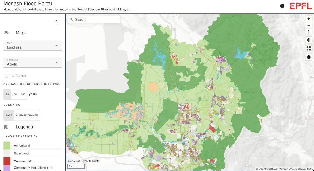
Many countries, including Switzerland and Malaysia, have recognised the importance of improving their flood management to minimise the hazards to human lives, property, and the environment. There is a clear need for an interdisciplinary effort for collaborative learning across research facilities, municipalities, and governments. Therefore, the main aim of our project was to develop a public flood web viewer to visualise the integrated flood risks in the Selangor River catchment study area under different scenarios, such as changes in land use and climate change projections. The web viewer (see screenshot above) is online at: https://monash-flood-portal.epfl.ch/
The methodology used in this work comprises multiple phases: (1) a systematic review of existing flood web viewers, (2) web viewer development, and (3) web viewer testing. For Phase 1, we evaluated 24 globally existing flood web viewers to identify trends and variations in data accuracy. The technology was also evaluated to gain a more thorough understanding of the programming languages, frameworks, and data storage systems in use. Following this, a summary of the compiled best practices was provided to identify potential user engagement strategies and features that can be incorporated into the flood web viewer. In Phase 2, we developed the first version of the flood web viewer. To facilitate the development of the flood web viewer, it was critical to comprehend the most effective way of conveying information via the web portal. We designed the prototype flood web viewer to create a user-friendly application that enables anyone without extensive prior knowledge to access it easily. For a more comprehensive risk assessment, our flood maps incorporate other variables, including topography, precipitation patterns, historical flood data, and soil composition. In Phase 3, we gathered stakeholders’ feedback on our web viewer. This required us to identify potential stakeholders, prepare interview materials and questions, and analyse the qualitative and quantitative data collected. The feedback we obtained is guiding further enhancements of the web viewer that are currently underway. The integration of flood maps is of significant value in long-term planning, as it empowers communities to identify areas prone to flooding and implement preventative measures. Educated communities are more likely to embrace flood-resilient practices, strengthening their overall disaster preparedness. This research is mapped to the United Nations Sustainable Development Goal 11: Make cities and human settlements inclusive, safe, resilient, and sustainable, and Goal 13: Take urgent action to combat climate change and its impacts. For Malaysia, this research is aligned with the Mid-Term Review of the Eleventh Malaysia Plan and part of the National Key Priority Areas in terms of climate change, healthy communities, and anchoring growth to people. This study also supports the National Disaster Management Agency (NADMA) in focusing on environmental sustainability to ensure the nation’s continued economic growth and resilience against climate change and disaster.
People: Meret Aeppli
Collaborators: Izni Mohd Zahidi (Monash University), ENAC IT4Research team (EPFL)
Funding: Research Partnership Grants ASEAN by Leading House Asia ETHZ
Project dates: February 2023 – January 2024