Context. The study of mass changes and energy fluxes across mountain environments has undergone a quantitative evolution, facilitated by the enhanced quality and quantity of available datasets (Passalacqua et al., 2015). In recent decades, surveying technologies capable of acquiring topography data with very high-resolution (decimetre and sub-decimetre resolution) have emerged. It is now possible to capture microscale features at an appropriate degree of granularity, thereby enabling the observation of small but frequent surface processes (e.g., Walter et al., 2022). The abundance of data obtained from Uncrewed Aerial Vehicles (UAV), which are equipped with various sensors (including laser scanners and metric cameras), offers significant opportunities for research and presents a number of challenges (e.g., Stark et al., 2021).
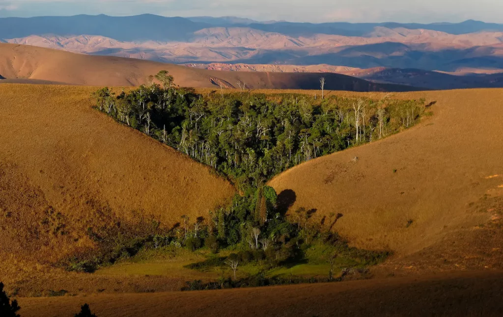
Objectives. This project proposes the utilisation of repeated very high-resolution topographic surveys for the quantification of landscape changes at the Arolla site in the Valais Alps. To this end, two exploratory UAV surveys were conducted in June and October 2024, employing a laser scanner and a metric camera at low altitude. It is anticipated that a minimum of two additional UAV surveys will be conducted during the summer-autumn period of 2025. The site is located on the western face of a valley side, where mudflows were triggered in 2018. The site comprises an active rock glacier and the morainic bastions of a former steep glacier system, which now provides a larger quantity of sediments to ephemeral mountain streams. The sites provide practical examples of how mountain landscapes can evolve rapidly during the current climate change.
If you are interested, please contact Sara Bonetti ([email protected]) and Sebastian Vivero ([email protected]).
3D model of La Roussette rock glacier: https://skfb.ly/pwKRZ

Context. Landscape topography and its time evolution play a crucial role in a variety of ecohydrological and geomorphological processes. For example, the spatial distribution of energy (e.g., radiation) and water (e.g., soil moisture) variables, which are the main drivers of vegetation and nutrients distribution, is highly dependent on the topographic features of a landscape (e.g., elevation, slope, aspect, curvature, drainage area) (Florinsky and Kuryakova, 1996). The amount of solar radiation intercepted by a surface is affected by local slope and aspect (Essery and Marks, 2007), while surface and subsurface water redistribution are strongly influenced by microtopographic attributes such as landscape connectivity, curvature, and slope, thus regulating the local soil moisture available to plants (Dymond et al., 2017). Conversely, vegetation cover influences landscape evolution in many ways, such as providing physical resistance to soil erosion and enhancing soil cohesion (Meng et al., 2022). Despite the significant progress in the past decades, the understanding of potential feedback mechanisms between vegetation and landforms, as mediated by local environmental and climatic conditions, is still limited.
Objectives. This thesis contributes to answering the question “how do vegetation and topography co-evolve”? The student will couple a state-of-the-art spatially distributed ecohydrological model (Tethys- Chloris, Fatichi et al., 2012) and a landscape evolution model (CAESAR-Lisflood, Coulthard et al., 2013) to quantify how landscape evolution impacts the spatial distribution of vegetation and, conversely, how vegetation distribution affects the landscape evolution dynamics. The student is expected to actively work on a literature review of the topic (10%), perform numerical simulations (70%) and critically assess the results (20%).
If you are interested, please contact Sara Bonetti ([email protected]) and Taiqi Lian ([email protected]).
Project 1. Landscape evolution, the study of how tectonic uplift, climate-driven erosion and sediment transport interact to shape Earth’s topography over geologic timescales, has long relied on simplified transport laws to predict long-term terrain development. Current reduced-order models accurately describe near-equilibrium landscapes by assuming shallow slopes and linear flux-slope relationships, which decouple vertical and horizontal scales and apply stream-power incision vertically rather than normal to the surface (Bonetti et al., 2020). In contrast, steep mountainous terrains exhibit nonlocal hillslope diffusion and surface-normal erosion processes (Ganti et al., 2012, Stark and Stark, 2022). This master’s thesis will implement and analyze 1D and 2D numerical models that incorporate far-from-equilibrium transport laws, specifically nonlocal diffusion and surface-normal stream-power, to quantify their effects on erosion dynamics and topographic evolution in steep landscapes. Ultimately, this work will improve predictions of sediment and soil-carbon fluxes in orogenic settings such as the Swiss Alps.
Project 2. Reduced-order landscape evolution models – used to examine how tectonic uplift, climate-driven erosion, and sediment transport interact to shape Earth’s topography over geologic timescales – depend on highly simplified equations for surface water dynamics. Recent studies (Gailleton et al., 2024, Coatleven and Chauveau, 2024} have advanced towards the integration of more physically realistic surface water formulations into these models. This master’s project will focus on incorporating such realistic hydrodynamic equations into reduced-order landscape evolution models, while preserving both computational efficiency and analytical tractability.
If you are interested, please contact Sara Bonetti ([email protected]) and Benjamin Kargere ([email protected]).
Context. Integrating the urban surface with Nature Based Solutions (NBS) and Blue Green Infrastructures (BGI) is becoming crucial in terms of achieving sustainability of cities and implementing solutions to major challenges such as climate change (Frantzeskaki, 2019). To deal with sustainable urban management, decision-makers can rely on tools that assess the advantages of urban greening, i.e., by quantifying the benefits of integrating natural features like parks, street trees, green roofs into the urban granularity (Hamel et al., 2021).
The cantonal roads in Switzerland, connecting city centers to the peripheral neighbors, represent a topical example in this context. Indeed, their vast surfaces contribute to soil sealing, disrupting rainwater absorption, harming biodiversity, and affecting the local microclimate. A multi-disciplinary approach combining climatic inputs and scenarios (e.g., future projections of temperature and rainfall), and biophysical indicators (e.g., for biodiversity) is thus required to inform urban planners and policy makers.
Objectives. This is a cooperative project with the public authorities in the canton of Fribourg (Switzerland) and the Atelier de la Conception de l’Espace (ALICE) (see also SURFACE project webpage). Within this project, you will evaluate the benefits of possible design solutions to improve several ecosystem services (such as urban cooling and urban heat island, flood risk, carbon sequestration and storage, biodiversity and crop pollination) in the canton of Fribourg. Depending on the ecosystem service to assess, different tools will be adopted, such as the InVEST model (Integrated Valuation of Ecosystem Services and Tradeoffs), the TARGET model (The Air Temperature Response to Green/blue-infrastructure Evaluation Tool, Broadbent et al., 2019), or hydrodynamic models such as HEC-RAS. The student is expected to perform numerical simulations to produce spatially-distributed maps, evaluate the impacts of different design or climate scenarios, perform sensitivity analyses, and critically assess the results. The student is expected to actively work on a literature review of the topic (10%), perform numerical simulations (70%) and critically assess the results (20%).
If you are interested, please contact Sara Bonetti ([email protected]) and Concetta D’Amato ([email protected]).
Context. Climate change poses a significant threat to the sustainability of agriculture, and climate-smart agricultural practices offer potential solutions to mitigate these effects (Lipper et al., 2014). The use of cover crops has emerged as a potential strategy to safeguard food production while reducing environmental impacts . While numerous studies have demonstrated the positive effects of cover crops on primary crop yields and soil organic carbon (SOC), these effects can vary based on factors such as climate, soil type, and crop species (Abdalla et al., 2019; Bai et al., 2019). To better understand the underlying mechanisms driving these effects, model-based simulations are essential.
Objectives. This project aims to investigate how various environmental factors influence the impact of cover crops on selected target variables (e.g., crop yield, soil organic carbon, nitrogen leaching). Utilizing the state-of-the-art T&C-crop model (Buckley Paules et al., 2024), the student will design and implement a range of environmental scenarios and conduct numerical simulations to uncover the underlying mechanisms driving these effects. The student is expected to actively work on a literature review of the topic (10%), perform numerical simulations (70%) and critically analysis the results (20%).
If you are interested, please contact Sara Bonetti ([email protected]) and Qiming Sun ([email protected]).
Context. The increasing pressures of climate change and nutrient pollution present significant challenges to sustainable agricultural practices. Efficient management of irrigation and fertilization is crucial for optimizing crop productivity while minimizing nutrient losses to the environment (Tufail et al., 2024). Recent advancements in eco-hydrological modeling provide valuable tools for analyzing these complex interactions. By leveraging state-of-the-art models, we can better understand the optimal timing of agricultural inputs to enhance both productivity and environmental sustainability.
Objectives. This project aims to explore the optimal timing of irrigation and fertilization in agricultural systems to reduce nutrient losses and maximize crop yield. Utilizing the cutting-edge T&C-Crop Model (Buckley Paules et al., 2024), the student will develop and simulate various irrigation and fertilization scenarios under different environmental conditions. The project will involve a literature review of current practices and their impacts (15%), conducting numerical simulations to assess the effects of timing on nutrient dynamics and crop productivity (65%), and critically analyzing the simulation results to derive actionable insights (20%).
The student will gain hands-on experience in eco-hydrological modeling and contribute to the development of sustainable agricultural practices.
If you are interested, please contact Sara Bonetti ([email protected]) and Felix Bauer ([email protected])
Projects on food security, irrigation, and diets – in collaboration with the Human-Water Systems Group (Prof. M. Müller) at EAWAG – are available upon request. f you are interested, please contact Sara Bonetti ([email protected]).
Completed master projects (PDMs):
- Formulation and implementation of a fully-implicit solver for a transport-limited landscape evolution model (2026), Mathilde Simoni, EPFL – CHANGE
- Hydrogeological modeling of a mountainous alluvial aquifer (Röthenbach, Switzerland) (2025), Raphaël Aubrun, EPFL – CHANGE, UNINE – CHYN
- Implications of changes in rainfall and temperature variability for Swiss and European maize production (2025), Juliette Salles, EPFL – CHANGE
- Scaling, minimization of net-free energy dissipation, and linear stability analysis of a transport-limited stream-power plus linear diffusion model (2025), Benjamin Kargère, EPFL-CHANGE
- Confronting long-term trends of irrigation and climate change to assess the efficiency of substitution reservoirs in the Marais Poitevin (2025), Mayaux Clémence Geneviève Janine, EPFL-CHANGE, CNRS Paris
- Hydrological modeling and integrated rainwater management strategies for adapting Charleroi to climate change (2024), Victor Deblon, EPFL – CHANGE, EcoRes (BE)
- Global assessment of agricultural water sustainability under future climate changes (2024), Qiming Sun, EPFL – CHANGE
- Quantifying uncertainty in agricultural water sustainability indicators for soybean and wheat crops (2023), Rémi Elian Raphaël Depalle, EPFL – CHANGE
- Simulating crop water and carbon dynamics: assessment of model performances (2023), David Simon-Vermot, EPFL – CHANGE
- Évaluation du ruissellement à l’échelle locale et analyse de l’efficacité de mesures de protection (2023), Lucas Lometti, EPFL – CHANGE and PL-LCH, CSD Ingénieurs (CH).
- Physical and numerical model study of the Trient Torrent from the gorges to the Rhone River (2023), Marie Joséphine Gaiffe, EPFL – CHANGE and PL-LCH.
Completed semester projects:
- Mapping carbon storage and crop pollination ecosystem services in the Canton of Fribourg (2026), Alexandra Knoblauch, SIE Individual Project
- Assessing urban heat mitigation in Fribourgwith the use of the InVest model (2025), June Rossen, Interdisciplinary Project in Sustainability
- Short-term monitoring of the Moiry glacier forefield (Valais, Alps) using repeated high-resolution topography (2025), Fulvia Malvido Montandon, SIE Individual Project
- Evaluation of ecosystem services provided by Fribourg’s cantonal roads (2024), Anthony Jean Michel Varaillon-Divanis, SIE Individual Project
- Hybrid modeling of stomatal resistance using a complex ecohydrological model and eddy covariance measurements (2024), Ismaïl Sahbane, IC Semester Project
- Quantifying the potential benefits of climate-smart agricultural practices (2024), Mikael Marcos Gonzalez, SIE Individual Project
- Impact of topography on catchment water and carbon dynamics (2024), Sven Henrioux, SIE Individual Project
- Effect of rainfall spatio-temporal variability on soil erosion dynamics (2024), Noemi Esther Steiger, SIE Individual Project
- Modeling stormwater treatment basin aging dynamics (2024), Rafik Tewfik, SIE Individual Project
- Water sustainability of Swiss crop imports (2023), Soren Tiago Rasmussen, SIE Individual Project
- Swiss water impact of imported maize and cocoa beans in their producing countries (2023), Sébastien Hill Rogers, SIE Individual Project