At the beginning we were a group of projects that became a community, partly thanks to the sharing of the data.
What is the project about?
The Antarctic Circumnavigation Expedition (ACE) was organised by the Swiss Polar Institute in the Southern Ocean during the austral summer of 2016 and 2017, with 22 different projects on board, ranging from chemistry to physics and biology. This was a special project as normally expeditions go repeatedly to one place to obtain time series to measure changes in parameters like salinity or precipitation.
Our project ATLACE (ATLantic interactions via atmospheric water cycle: exploiting a unique dataset from the Antarctic Circumnavigation Expedition (ACE)), was first led by Katherine Leonard, and then taken over by Michael Lehning. It focused on precipitation over the Southern Ocean, which there is surprisingly not a lot of data on, it is a very undermeasured parameter. We also took data on clouds and meteorology (how precipitation forms, its properties, etc.) by launching radio sondes, to have the vertical profile of the atmosphere up to 30 km. We got the first measurements of cloud super cooled liquid water content over the Southern Ocean. We also measured isotopes on the water surface and got measurements at different depths with rosette samplers.
The project was endorsed by the Year of Polar Prediction international initiative for its contribution to the open data and science, you can see the list of endorsed projects and our endorsement.
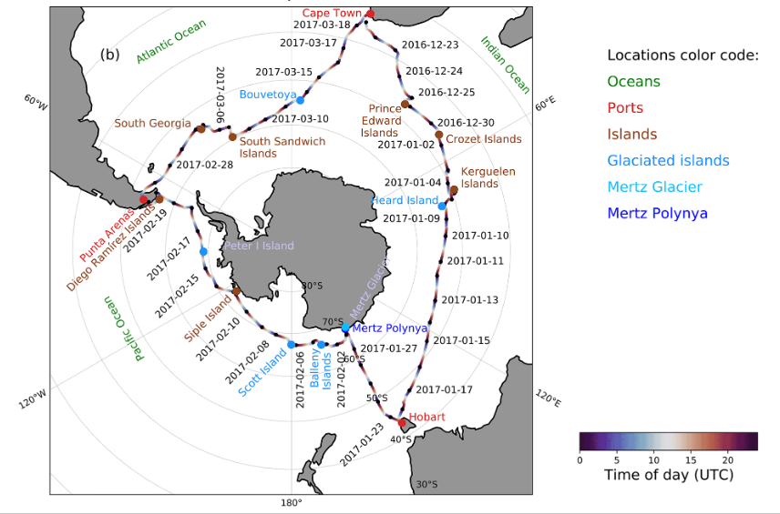
Image from: https://doi.org/10.5194/esd-12-1295-2021, CC BY 4.0
We used a multi-sensor approach, with a collaboration with other ETH projects, using for example radars or photoelectric particle counters to measure precipitation and snow. Data was very diverse, there was continuous automatic measurements and discrete data (for example from the radio sondes), in a specific time and place. We also had digitised images like snowflakes.
After the Expedition, the team continued working with the data, as it is shown in this publication, we gathered 30 TB of data and 27 thousand samples.
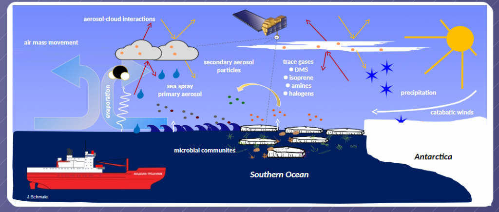
By Julia Schmale, CC BY 4.0
Why Open?
One of the main objectives of the Expedition was for all the projects on board to measure their data and make it openly available for the rest of the experiments or anyone else interested to foster multidisciplinary projects, even if each one of the 22 projects had a defined and separate scientific objective. We each do our work on our project, but other people can apply the data in different ways or for different ideas, as a service for the community.
Nowadays, data sharing is actually a requirement for these programs as everything collected below 60 degrees South has to be publicly available. The Research Antarctic research program also made it obligatory to follow the FAIR principles, to increase harmonisation and accessibility. This is very important as we lack measurements and data is very valuable. Expeditions require a lot of money, logistics and time.
Who benefits from it?
All the experiments on the Expedition are capable at looking at the data from other experiments, so we are able to write multidisciplinary collaborative papers. At the beginning we were a group of projects that became a community, partly thanks to the sharing of the data. While working on a publication, we would be looking at other data, learning how different parameters are interconnected.
There is more value for the community, as this was not available before, as before only publications matter, now we see the importance of data and especially on open data
How did you make it the data open?
During the expedition, there were two data managers on board that helped with all the data acquisition and also to make data openly available. They also organised and helped the teams to, after collecting the data, prepare it to be used by others, not only for the project researchers. This made a big difference. Jean Thomas was with the Swiss Polar institute, helping with protocols and repositories. The post-processing takes time but after datasets are more easily reusable.
All the data from the expedition was put on Zenodo repositories, harmonising format as much as possible and following guidelines for each kind of data if necessary. We were given protocols on how to do this by the data managers.
Some of our data that can be found in Zenodo include atmospheric profiling data collected from radiosondes, particle size distribution data collected using a snow particle counter, seawater stable isotope sample measurements or meteorological data. We published all raw data and processed data sets. In the publications, all the data links are mentioned so anyone can reuse the data. There are different people managing the data and that is detail (collector, managers…), we have version tracking and thorough data information (version, type, contact information, etc.).
This is described for example in this multidisciplinary publication connecting various ACE projects, making all data openly available and applying them to different fields.
The ACE project collected the data and we are continuing to use it more than 6 years later for publications. At ATLACE for example, we are still publishing post-processed data sets from ACE.
Contact: Irina Gorodetskaya