Available Projects
Airborne laser scanning (ALS) is a widely adopted remote sensing technology, renowned for its efficient and precise modeling of forests. This is attributed to its capability to accurately describe the geometric features of trees within a forest. However, automating the identification of individual trees and their species from ALS data poses a formidable challenge. Traditional closed-form clustering algorithms yield inaccurate segmentation results, and deep learning-based methods demand substantial amounts of labeled training data, which is impractical to establish manually.
This project aims to tackle the challenges associated with object labeling and accuracy by employing unsupervised and self-supervised approaches. Unsupervised methods are utilized to obtain a preliminary segmentation of the ALS data. Subsequently, these roughly segmented tree examples will be hand labeled and employed to train a classifier, facilitating the identification of well-segmented tree individuals. In the final step, these labels will be used to calibrate and refine state of the art segmentation and classification algorithms, employing a semi-supervised approach.
This project investigates the application of guided super-resolution techniques for monitoring canopy dynamics on the EPFL campus, supporting the university’s Climate and Sustainability Strategy 2030. Using high-resolution LiDAR and RGB data acquired in June 2024 as a pseudo ground-truth, the study explores how lower-resolution satellite and airborne imagery can be enhanced through guided methods to improve canopy index estimation. By combining super-resolution with canopy estimation pipelines based on deep learning or indices, the project aims to establish a workflow that is both accurate and reproducible across multiple years.
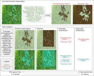
This project focuses on designing a weak-validation framework for zero-shot semantic segmentation models applied to biodiversity imaging. The objective is to evaluate the ability of these models to identify and localize living species using weakly annotated datasets. Relevant fine-grained and large-scale species datasets will be selected and integrated into a unified evaluation pipeline. The framework will include tools for dataset handling, prediction transformation, and metric computation. Existing state-of-the-art segmentation models will then be evaluated using the proposed methodology. The project aims to support research in weakly-supervised computer vision for ecological and biodiversity applications.
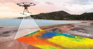
Hyperspectral cameras are used to produce remote sensing data for snow cap monitoring, forests management and other important field. They can reveal hidden information not available by using just light in the visual spectrum. But they tend to be heavier than RGB cameras, and since they acquire a single line of pixel at a time, are reliant on accurate georeferencing information to build usable orthoimages from the acquisition data.
The Resonon PikaL is a minature hyperspectral camera, designed to be deployed a payload on UAV. The goal of this project is to improve the acquisition firmware to :
- ensure accurate synchronization between exposition frames from the camera, and the navigation computer of the platform used for flight.
- possibly allow the camera to be flown with a smaller processing computer, and direct integration with the drone navigation system, increasing the payload capacity of the platform for other sensors.
In this project, you will contribute on improving a real car-mounted laser scanning system.
The project will focus on adapting a deep learning methodology developed in our lab and able to recognize correspondences (i.e. recognizable points scanned multiple times in a point cloud). These correspondences can then be leveraged to refine the estimation of the trajectory of the vehicle. The end goal is to improve the robustness of the trajectory estimation and point cloud generation pipeline when GNSS signal degradation occurs, allowing for more accurate 3D digitization of scanned areas.